Tropical Storm Isaias Latest Update: Storm Strengthens in Gulf, Hurricane Forecast Thursday
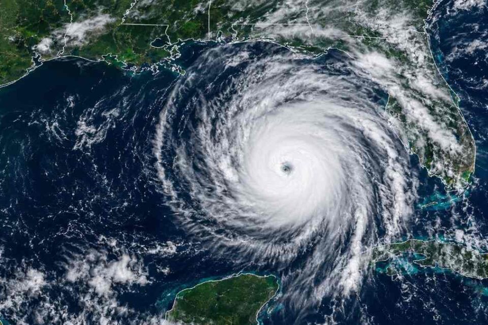
Tropical Storm Isaias latest news: Tropical Storm Isaias is strengthening rapidly over the Gulf of Mexico and is forecast to become a hurricane by Thursday morning, according to the National Hurricane Center. The storm is moving toward the northern Gulf Coast, where hurricane and storm surge watches are already in effect for parts of the coast.
Residents along the northern Gulf Coast should closely monitor official forecasts because the storm’s intensity, size and track can still change before landfall.
Tropical Storm Isaias Latest Update
According to the National Hurricane Center’s latest advisory, Isaias had maximum sustained winds of 65 mph and was moving east-northeast at about 8 mph.
The center of the storm was located near 22.7°N, 92.9°W, about 225 miles west-northwest of Progreso, Mexico, and approximately 500 miles south-southwest of the mouth of the Mississippi River.
NHC forecasts Isaias to continue strengthening and become a hurricane by Thursday morning, with additional strengthening possible through Friday morning.
Where Is Tropical Storm Isaias Right Now?
Isaias is currently over the Gulf of Mexico and moving east-northeast.
The storm is expected to pass north of the Yucatan Peninsula on Thursday before turning more toward the northeast and north. The current NHC forecast calls for Isaias to reach the northern Gulf Coast late Friday or early Saturday.
Because tropical cyclone tracks can shift, residents should continue checking the latest National Hurricane Center and local National Weather Service updates.
Will Isaias Become a Hurricane?
Yes. The National Hurricane Center is forecasting Isaias to become a hurricane by Thursday morning.
The storm is already strengthening over warm Gulf waters, and NHC expects further intensification through Friday morning. However, the eventual strength at landfall can still change because tropical cyclones are affected by atmospheric conditions, wind shear and other environmental factors.
Hurricane Isaias Track
The forecast track continues to take Isaias toward the northern Gulf Coast.
A Hurricane Watch is currently in effect from Bay St. Louis, Mississippi, to Indian Pass, Florida, while a Storm Surge Watch extends from the mouth of the Mississippi River to Yankeetown, Florida.
The exact center of the storm could still move east or west of the current forecast track. Communities outside the projected center can also experience dangerous weather.
Potential Landfall Area
The National Hurricane Center currently expects Isaias to make landfall along the U.S. northern Gulf Coast late Friday or early Saturday.
The precise landfall location remains uncertain, so residents across the watch areas should not wait for the storm’s final track before completing preparations.
Local emergency officials may issue additional watches, warnings or evacuation instructions as the storm gets closer.
Storm Surge Could Be a Major Threat
Storm surge is one of the most dangerous hazards associated with a tropical cyclone.
A combination of storm surge and tides can push seawater inland and cause life-threatening flooding in coastal areas.
Residents in coastal and low-lying locations should take storm surge watches seriously and follow instructions from local emergency-management officials.
Heavy Rain and Flooding
Isaias could also produce heavy rainfall along portions of the Gulf Coast and farther inland.
Tropical cyclone rain bands can produce rapid flooding, especially in low-lying and poorly drained areas. Flooding may continue even after the storm’s center moves inland.
Drivers should never attempt to cross a flooded road. Water can be deeper and faster-moving than it appears.
Tropical Storm Isaias Wind Threat
As Isaias strengthens, the risk of damaging winds will increase.
Hurricane-force winds could damage roofs, trees, power lines and other infrastructure near the storm’s stronger core. Even tropical-storm-force winds can cause power outages, dangerous travel conditions and property damage.
Residents should secure outdoor furniture, loose objects and other items before strong winds arrive.
Tornado Threat
The National Hurricane Center warns that tornado potential could increase as Isaias’ rain bands approach the northeastern Gulf Coast Friday evening and overnight.
That tornado risk could spread farther inland on Saturday as the storm moves north.
Residents should monitor local weather alerts and have a way to receive emergency warnings during the storm.
What Residents Should Do Now
Residents in areas affected by the watches should begin or complete storm preparations before conditions deteriorate.
Keep several days of food and drinking water available, charge phones and backup batteries, secure loose outdoor objects, protect important documents, and know your evacuation route.
People in evacuation zones should be prepared to leave when instructed by local authorities.
Is Tropical Storm Isaias Dangerous?
Yes. Isaias has the potential to produce dangerous conditions along parts of the northern Gulf Coast.
The main threats include strong winds, storm surge, coastal flooding, heavy rainfall, flash flooding and potentially tornadoes.
A community does not need to experience a direct landfall to see hazardous weather from a tropical cyclone.
Tropical Storm Isaias Latest Forecast
The most important factors to watch in the next several forecast updates are:
- Whether Isaias reaches hurricane strength Thursday.
- How strong the storm becomes over the Gulf.
- Any east or west shift in the forecast track.
- The eventual landfall location.
- Storm surge and coastal flooding projections.
- Rainfall, flash-flood and tornado risks.
Because the storm is strengthening quickly, older forecast maps can become outdated. Residents should rely on the latest National Hurricane Center and local National Weather Service information.
Tropical Storm Isaias FAQs
Is Isaias a hurricane right now?
As of the latest NHC advisory checked for this article, Isaias is a Tropical Storm with maximum sustained winds of 65 mph. NHC forecasts it to become a hurricane by Thursday morning.
Where is Isaias expected to go?
The storm is forecast to move toward the northern Gulf Coast after passing north of the Yucatan Peninsula. The current forecast calls for a U.S. Gulf Coast landfall late Friday or early Saturday.
When could Isaias make landfall?
The current forecast calls for landfall along the U.S. northern Gulf Coast late Friday or early Saturday, but the exact timing and location may change.
What are the biggest threats from Isaias?
Potential threats include hurricane-force winds, storm surge, coastal flooding, heavy rainfall, flash flooding and tornadoes.
Should Gulf Coast residents evacuate?
Residents should follow instructions from local emergency officials. Anyone in a designated evacuation area should be prepared to leave when an evacuation order is issued.
Bottom Line
Tropical Storm Isaias is rapidly strengthening over the Gulf of Mexico and is forecast to become a hurricane by Thursday morning. The storm is expected to approach the northern Gulf Coast late Friday or early Saturday.
With hurricane and storm surge watches already in effect for parts of the coast, residents should continue monitoring official forecasts and complete preparations now rather than waiting for the final track.